Country shapes: Asia quiz

From sprawling giants to scattered archipelagos and jagged mountain states, Asia's outlines are a real test of map-reading. Name these 20 countries from their silhouettes alone, each drawn to its true shape.

A free quiz from Megan Moran, author of The Mighty Geography Quiz Book.

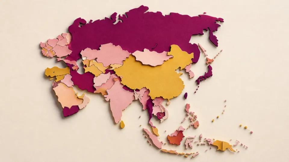
Paper-cut map of a large continent made from countries in plum, gold and pink
Pick an answer to start20 to go
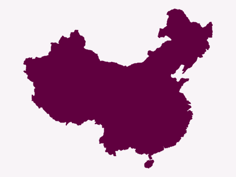
  1. Silhouette of a vast country with a long eastern coastline, a large lobe in the north-east and an island off its southern coast
    Natural Earth (map data) · Public domain

    Question 1 of 20Country shapes: AsiaEasy

    Which country has this shape?

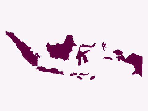
  2. Silhouette of a long chain of islands stretching from west to east, from a long island in the west to half of a large island in the east
    Natural Earth (map data) · Public domain

    Question 2 of 20Country shapes: AsiaEasy
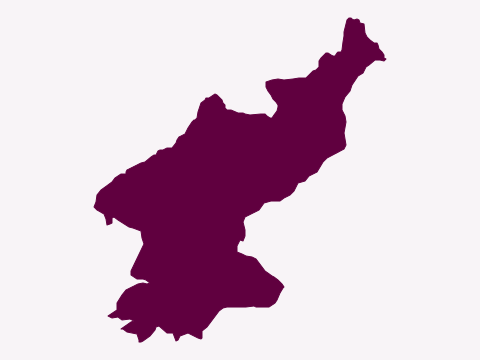
    Which country has this shape?

  3. Silhouette of a country with a long, ragged northern border, narrowing to the south, with coastlines on both its east and west sides
    Natural Earth (map data) · Public domain

    Question 3 of 20Country shapes: AsiaMedium
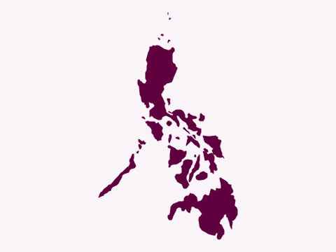
    Which country has this shape?

  4. Silhouette of a cluster of many islands, with a large island in the north, a long, thin island to the west and a large island in the south
    Natural Earth (map data) · Public domain

    Question 4 of 20Country shapes: AsiaEasy
    Which country has this shape?

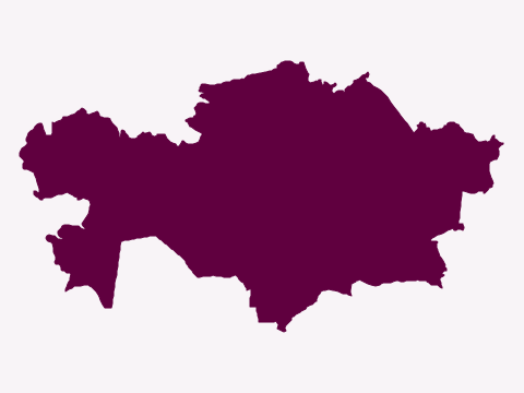
  5. Silhouette of a very wide, landlocked country with a ragged western edge and a narrower eastern end
    Natural Earth (map data) · Public domain

    Question 5 of 20Country shapes: AsiaMedium
    Which country has this shape?

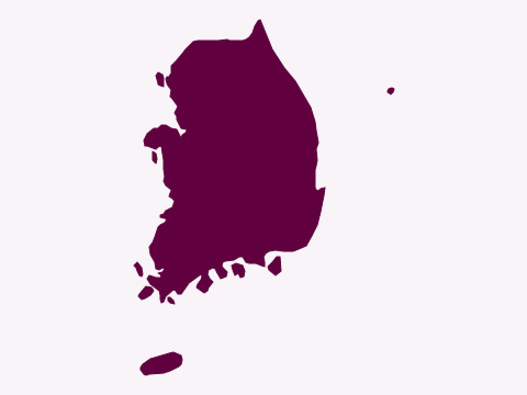
  6. Silhouette of the southern part of a peninsula, with many small islands off its south and west coasts and a larger oval island further south
    Natural Earth (map data) · Public domain

    Question 6 of 20Country shapes: AsiaEasy
    Which country has this shape?

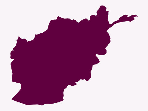
  7. Silhouette of a landlocked country with a long, thin finger of land stretching out to the north-east
    Natural Earth (map data) · Public domain

    Question 7 of 20Country shapes: AsiaMedium
    Which country has this shape?

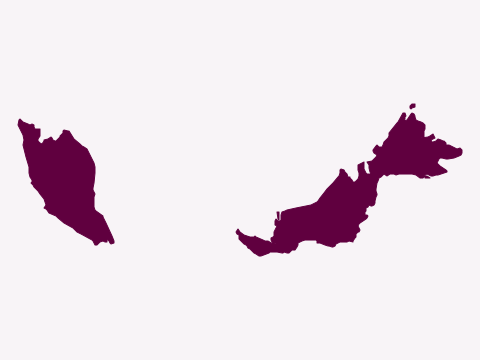
  8. Silhouette of a country in two parts: a narrow peninsula in the west and a larger area across the sea to the east
    Natural Earth (map data) · Public domain

    Question 8 of 20Country shapes: AsiaEasy
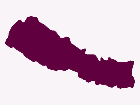
    Which country has this shape?

  9. Silhouette of a long, narrow landlocked country, roughly rectangular and tilted from north-west to south-east
    Natural Earth (map data) · Public domain

    Question 9 of 20Country shapes: AsiaMedium
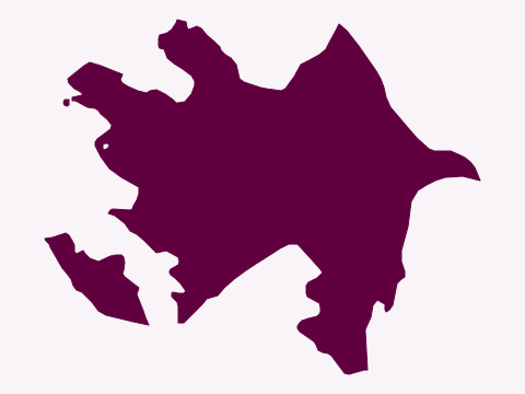
    Which country has this shape?

  10. Silhouette of a country with a pointed peninsula on its eastern coast and a separate piece of land to the south-west
    Natural Earth (map data) · Public domain

    Question 10 of 20Country shapes: AsiaHard
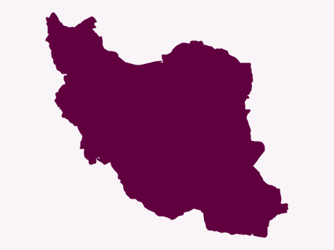
    Which country has this shape?

  11. Silhouette of a large country with a dip in its northern edge, a narrow north-western corner and a long coastline in the south
    Natural Earth (map data) · Public domain

    Question 11 of 20Country shapes: AsiaEasy
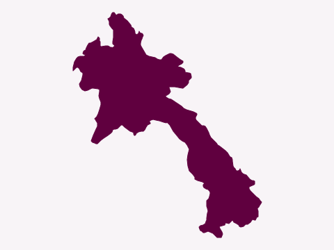
    Which country has this shape?

  12. Silhouette of a landlocked country with a wide northern part and a long arm running down to the south-east
    Natural Earth (map data) · Public domain

    Question 12 of 20Country shapes: AsiaMedium
    Which country has this shape?

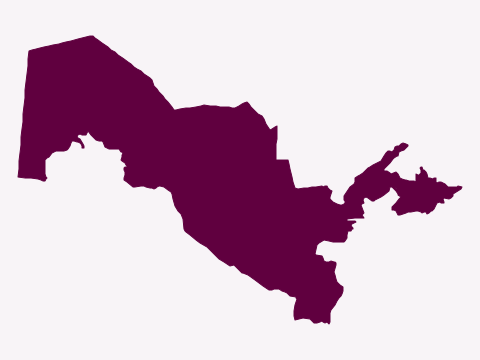
  13. Silhouette of a landlocked country with a wide, squarish western part and a narrow, jagged arm reaching east to a small lobe
    Natural Earth (map data) · Public domain

    Question 13 of 20Country shapes: AsiaHard
    Which country has this shape?

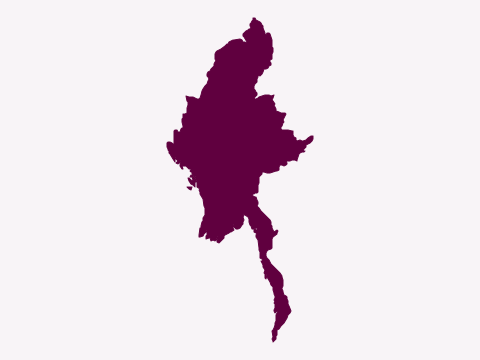
  14. Silhouette of a country with a large, diamond-shaped main part and a long, thin tail running south down the coast
    Natural Earth (map data) · Public domain

    Question 14 of 20Country shapes: AsiaMedium
    Which country has this shape?

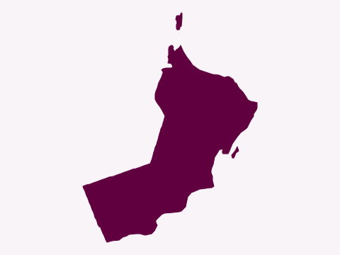
  15. Silhouette of a coastal country curving around the corner of a peninsula, with a small separate piece of land to the north
    Natural Earth (map data) · Public domain

    Question 15 of 20Country shapes: AsiaMedium
    Which country has this shape?

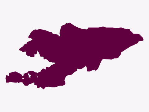
  16. Silhouette of a landlocked country with a broad eastern part and a long, ragged arm stretching to the south-west
    Natural Earth (map data) · Public domain

    Question 16 of 20Country shapes: AsiaHard
    Which country has this shape?

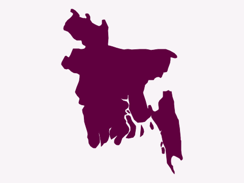
  17. Silhouette of a country with a ragged, island-strewn southern coast and a thin strip running down its south-eastern side
    Natural Earth (map data) · Public domain

    Question 17 of 20Country shapes: AsiaMedium
    Which country has this shape?

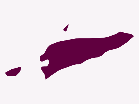
  18. Silhouette of a long, narrow strip of island, with a small separate piece of land to the west and a smaller island to the north
    Natural Earth (map data) · Public domain

    Question 18 of 20Country shapes: AsiaHard
    Which country has this shape?

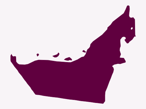
  19. Silhouette of a coastal country with a long northern coastline dotted with small islands and a point jutting up to the north-east
    Natural Earth (map data) · Public domain

    Question 19 of 20Country shapes: AsiaMedium
    Which country has this shape?

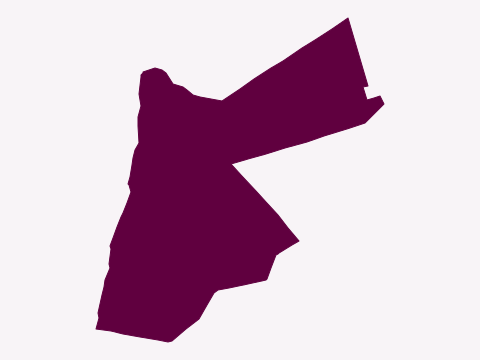
  20. Silhouette of a country with a tiny coastline at its southern tip and a long arm of land reaching out to the north-east
    Natural Earth (map data) · Public domain

    Question 20 of 20Country shapes: AsiaHard

    Which country has this shape?

Answer all 20 to see your score.

Want more? The Mighty Geography Quiz Book has over 1,000 questions like these, ready for your next quiz night.
Show all the answers, with the facts behind them
  1. Which country has this shape? ChinaChina spans five geographical time zones but uses a single official one, Beijing Time (UTC+8).
  2. Which country has this shape? IndonesiaIndonesia is the world's largest archipelagic state, with anywhere from about 13,000 to more than 17,000 islands, depending on how they are counted.
  3. Which country has this shape? North KoreaPaektu Mountain, a volcano on the border with China, is North Korea's highest peak and has a crater lake called Heaven Lake.
  4. Which country has this shape? PhilippinesThe name honors Philip II of Spain: in 1543 Ruy López de Villalobos's expedition called Leyte and Samar 'Felipinas' after the then crown prince.
  5. Which country has this shape? KazakhstanKazakhstan is the largest landlocked country in the world by area.
  6. Which country has this shape? South KoreaHallasan, a volcano on Jeju Island, is South Korea's highest mountain at 1,947 meters.
  7. Which country has this shape? AfghanistanThe Wakhan Corridor, the narrow north-eastern finger, was created in the 1890s to keep the Russian and British empires from touching.
  8. Which country has this shape? MalaysiaThe Petronas Towers in Kuala Lumpur were the tallest buildings in the world from 1998 to 2004.
  9. Which country has this shape? NepalNepal's flag is the only non-rectangular national flag in the world, and the only one that is taller than it is wide.
  10. Which country has this shape? AzerbaijanIts capital, Baku, lies 28 meters below sea level, making it the lowest-lying national capital in the world.
  11. Which country has this shape? IranIn 1935 the government asked foreign diplomats to stop using the name Persia and call the country Iran instead.
  12. Which country has this shape? LaosUS bombing between 1964 and 1973 made Laos the most heavily bombed country in history relative to the size of its population.
  13. Which country has this shape? UzbekistanUzbekistan is usually counted as one of only two doubly landlocked countries in the world; the other is Liechtenstein.
  14. Which country has this shape? MyanmarIn 2005 Myanmar moved its seat of government from Yangon to Naypyidaw, a new capital built for the purpose.
  15. Which country has this shape? OmanFrankincense trees still grow in southern Oman, and the ancient sites of its incense trade are a UNESCO World Heritage Site.
  16. Which country has this shape? KyrgyzstanIssyk-Kul is the world's second-largest mountain lake, and its salty water rarely freezes despite the bitter winters.
  17. Which country has this shape? BangladeshBangladesh holds about 60% of the Sundarbans, the world's largest continuous mangrove forest, which it shares with India.
  18. Which country has this shape? Timor-LesteOn 20 May 2002, Timor-Leste became the first new sovereign state of the 21st century.
  19. Which country has this shape? United Arab EmiratesThe country is a federation of seven emirates, of which Abu Dhabi is by far the largest.
  20. Which country has this shape? JordanThe ancient city of Petra was carved into rose-tinted sandstone cliffs by the Nabataeans, earning it the nickname 'Rose City'.