Country shapes: the Americas quiz

From continent-sized giants to tiny tropical islands, the Americas are full of memorable outlines. Can you name these 20 countries from their silhouettes alone? Each is drawn to its true shape.

A free quiz from Megan Moran, author of The Mighty Geography Quiz Book.

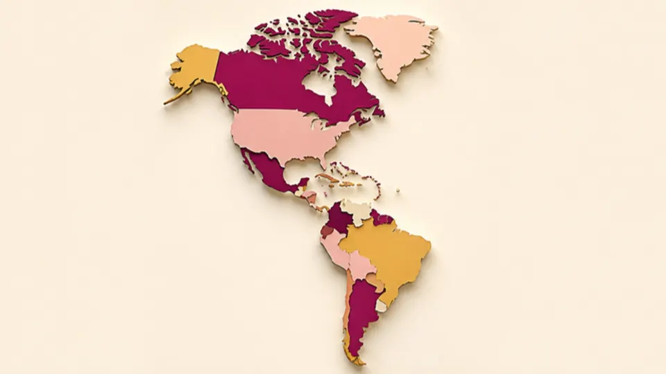
Paper-cut map of two linked continents made from countries in plum, gold and pink
Pick an answer to start20 to go
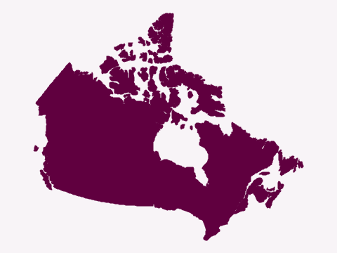
  1. Silhouette of a vast country with a long, straight southern border, a huge bay in the north-east and many large Arctic islands
    Natural Earth (map data) · Public domain

    Question 1 of 20Country shapes: the AmericasEasy

    Which country has this shape?

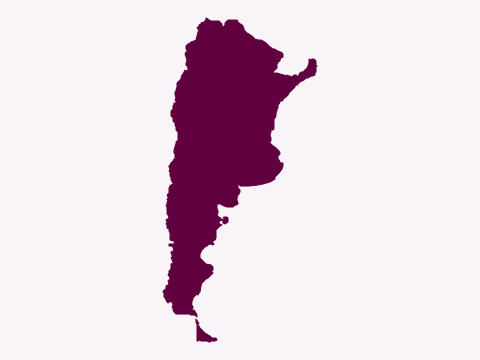
  2. Silhouette of a long country, wide in the north and tapering to the south, with an island at its southern tip
    Natural Earth (map data) · Public domain

    Question 2 of 20Country shapes: the AmericasEasy

    Which country has this shape?

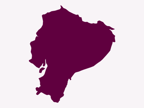
  3. Silhouette of a small coastal country with a rounded eastern side and a ragged western coastline with a gulf in the south
    Natural Earth (map data) · Public domain

    Question 3 of 20Country shapes: the AmericasMedium

    Which country has this shape?

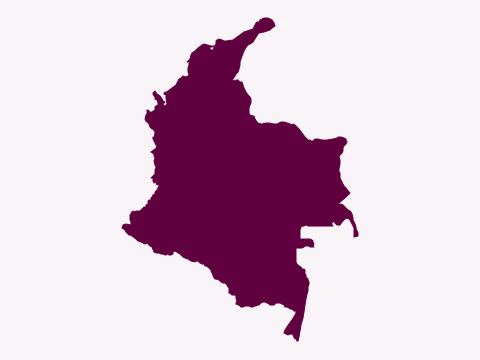
  4. Silhouette of a country with coastlines meeting at its north-western corner and a long, thin point reaching down to the south-east
    Natural Earth (map data) · Public domain

    Question 4 of 20Country shapes: the AmericasEasy

    Which country has this shape?

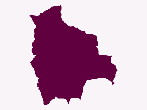
  5. Silhouette of a large landlocked country with a rounded northern half and a straight-edged lobe on its south-eastern side
    Natural Earth (map data) · Public domain

    Question 5 of 20Country shapes: the AmericasMedium

    Which country has this shape?

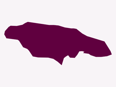
  6. Silhouette of a single, oval-shaped island stretched out from west to east
    Natural Earth (map data) · Public domain

    Question 6 of 20Country shapes: the AmericasEasy

    Which country has this shape?

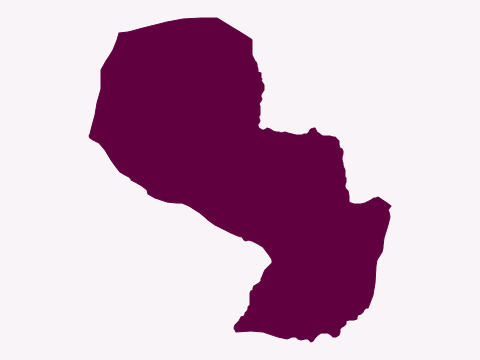
  7. Silhouette of a landlocked country made of two lobes, a larger north-western part and a smaller south-eastern part, joined in the middle
    Natural Earth (map data) · Public domain

    Question 7 of 20Country shapes: the AmericasMedium

    Which country has this shape?

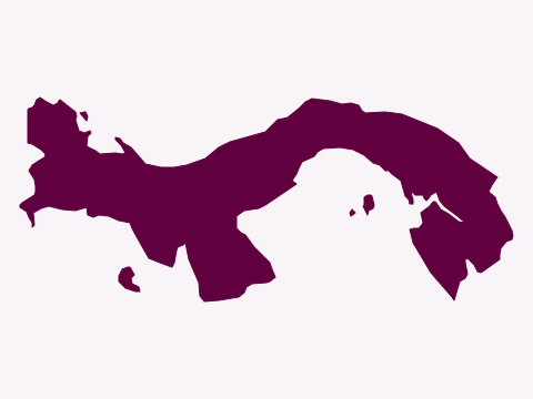
  8. Silhouette of a long, narrow country curving in an S shape from west to east, with a deep bay on its southern side
    Natural Earth (map data) · Public domain

    Question 8 of 20Country shapes: the AmericasEasy

    Which country has this shape?

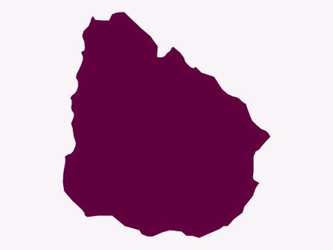
  9. Silhouette of a small, rounded country with a coastline along its southern and south-eastern sides
    Natural Earth (map data) · Public domain

    Question 9 of 20Country shapes: the AmericasMedium

    Which country has this shape?

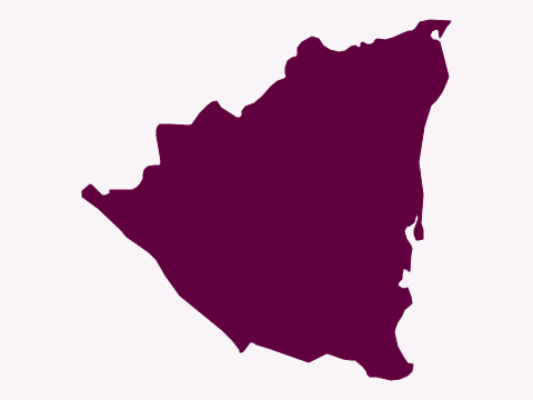
  10. Silhouette of a roughly triangular country with a long, straight-ish eastern coast and a shorter coast in the south-west
    Natural Earth (map data) · Public domain

    Question 10 of 20Country shapes: the AmericasHard

    Which country has this shape?

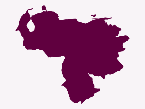
  11. Silhouette of a country with a long northern coastline, a deep inlet in the north-west and a large bulge extending to the south
    Natural Earth (map data) · Public domain

    Question 11 of 20Country shapes: the AmericasEasy
    Which country has this shape?

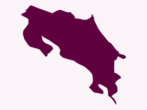
  12. Silhouette of a small country running from north-west to south-east, with two peninsulas on its south-western coast
    Natural Earth (map data) · Public domain

    Question 12 of 20Country shapes: the AmericasMedium
    Which country has this shape?

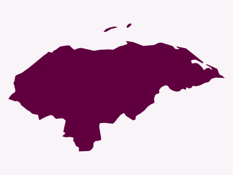
  13. Silhouette of a country with a long northern coastline, a pointed eastern tip, a few small islands offshore and a short coast in the south
    Natural Earth (map data) · Public domain

    Question 13 of 20Country shapes: the AmericasHard

    Which country has this shape?

  14. Silhouette of a horseshoe-shaped country with two long peninsulas pointing west and an island in the bay between them
    Natural Earth (map data) · Public domain

    Question 14 of 20Country shapes: the AmericasMedium
    Which country has this shape?

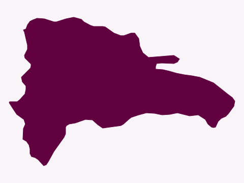
  15. Silhouette of the eastern part of an island, with a fairly straight western border and a peninsula in the north-east
    Natural Earth (map data) · Public domain

    Question 15 of 20Country shapes: the AmericasMedium
    Which country has this shape?

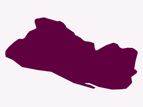
  16. Silhouette of a small country, about twice as wide as it is tall, with a long southern coastline
    Natural Earth (map data) · Public domain

    Question 16 of 20Country shapes: the AmericasHard

    Which country has this shape?

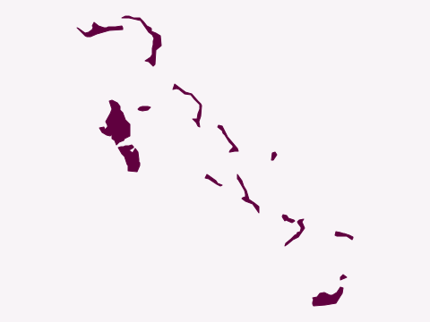
  17. Silhouette of a long, scattered chain of small, thin islands running from north-west to south-east
    Natural Earth (map data) · Public domain

    Question 17 of 20Country shapes: the AmericasMedium
    Which country has this shape?

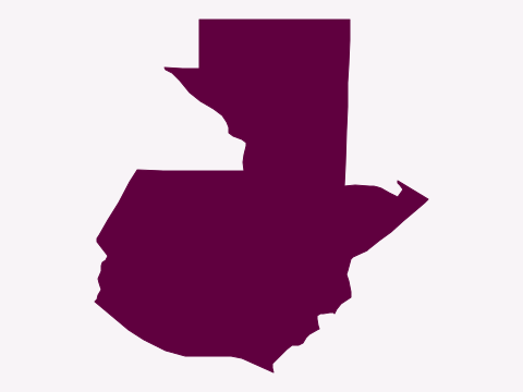
  18. Silhouette of a country with a squared-off northern part, a very short coast in the east and a longer coast in the south-west
    Natural Earth (map data) · Public domain

    Question 18 of 20Country shapes: the AmericasHard

    Which country has this shape?

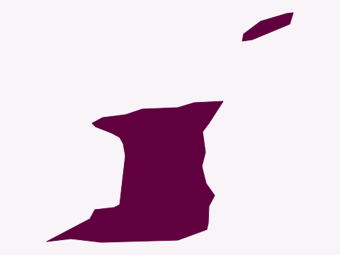
  19. Silhouette of a squarish island with peninsulas at its north-west and south-west corners, and a smaller island to its north-east
    Natural Earth (map data) · Public domain

    Question 19 of 20Country shapes: the AmericasMedium

    Which country has this shape?

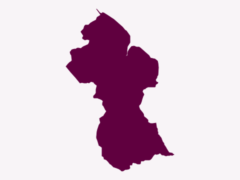
  20. Silhouette of a country with a coastline in the north-east, a narrow waist in the middle and a wider southern part
    Natural Earth (map data) · Public domain

    Question 20 of 20Country shapes: the AmericasHard
    Which country has this shape?

Answer all 20 to see your score.

Want more? The Mighty Geography Quiz Book has over 1,000 questions like these, ready for your next quiz night.
Show all the answers, with the facts behind them
  1. Which country has this shape? CanadaCanada has the longest coastline of any country in the world, at more than 200,000 km.
  2. Which country has this shape? ArgentinaAconcagua, in the Andes, is the highest mountain outside Asia, at almost 7,000 meters.
  3. Which country has this shape? EcuadorThe country takes its name from the Equator, which passes just north of its capital, Quito. The Galápagos Islands aren't shown.
  4. Which country has this shape? ColombiaColombia has a greater diversity of hummingbirds than any other country on Earth.
  5. Which country has this shape? BoliviaBolivia has two capitals: Sucre is the constitutional capital, while La Paz is the seat of government.
  6. Which country has this shape? JamaicaThe island's Blue Mountains give their name to Blue Mountain coffee, one of the most famous and expensive coffees in the world.
  7. Which country has this shape? ParaguayParaguay's flag is the only national flag with a different design on each side: the national seal on the front and the treasury seal on the back.
  8. Which country has this shape? PanamaThe canal, opened in 1914, lets ships pass between the Atlantic and Pacific without sailing around South America.
  9. Which country has this shape? UruguayUruguay hosted and won the first FIFA World Cup, in 1930.
  10. Which country has this shape? NicaraguaLake Nicaragua, the largest freshwater lake in Central America, is home to bull sharks that swim up from the sea.
  11. Which country has this shape? VenezuelaAngel Falls is usually described as the world's tallest uninterrupted waterfall, with a single sheer drop of 807 meters.
  12. Which country has this shape? Costa RicaCosta Rica abolished its army after a short civil war in 1948, and its 1949 constitution bans a permanent military.
  13. Which country has this shape? HondurasThe ancient Maya city of Copán, in the west of Honduras, is a UNESCO World Heritage Site famous for its carved stone monuments.
  14. Which country has this shape? HaitiIn 1804 Haiti became the first sovereign state in the Caribbean, and it is the only country ever founded by a slave revolt.
  15. Which country has this shape? Dominican RepublicSanto Domingo, the capital, is the oldest continuously inhabited European settlement in the Americas.
  16. Which country has this shape? El SalvadorEl Salvador is the only Central American country with no Caribbean coastline.
  17. Which country has this shape? The BahamasChristopher Columbus's first landfall in the Americas, in 1492, is generally thought to have been on San Salvador, one of these islands.
  18. Which country has this shape? GuatemalaTikal, in the northern rainforest, was one of the largest cities of the ancient Maya civilization.
  19. Which country has this shape? Trinidad and TobagoPitch Lake, on Trinidad, is a natural lake of asphalt that is still fed by crude oil seeping up from underground.
  20. Which country has this shape? GuyanaGuyana is the only country in mainland South America with English as its official language.